Alaska 2021 - July 1
– July 5
We left Sitka on July 1 in foggy, cool weather headed for
Kalinen Bay but the water was not good so we ended up in an unnamed cove north
of Kukul Narrows on Chichagof Island.

We had the chance to explore the beach and also go fishing
for an hour – Ling Cod for dinner tonight!


We woke up on the 2nd
and decided we could go outside of Chichagof Island – rollers but not terrible
so we headed to Waterfall Cove. One of the tricky things about this area is the
rocks! Piehle Passage is listed in the Douglas book as a passage hat requires
careful piloting in good visibility and fair weather only. The advantage of
Piehle Passage is that you avoid about 6 miles of open water. I took a picture
of our chart to show you the passage. We don’t chart our exact course since
much of the time we have to watch the water as we have found the charts are
very inaccurate in this area but it gives you an idea of where we are
navigating. The dotted line shows our path thru the Passage and the pictures
show you what it looks like from the boat.


These are photos of the outside just before we entered
Piehle Passage.


Waterfall cove is a
beautiful bay that has views of the 300 – 400 Foot Cascade Kasnyku Falls which
drops into the bay. We also went exploring an old site that we had seen in 2016
that had a lot of old mining equipment including a Pelton that Glen really
wanted to take home. It weighed about 800 pounds (just a guess) and we spent a
good hour freeing it from the tree that had embedded itself in the waterwheel.
We managed to free it and move it bout 8 feet but with over 200 feet to go and
also getting it into the metal boat was going to be problematic so we took a
picture and left it in the forest!


From here we moved on
to Klag Bay which is an area that is great for exploring ashore since there are
so many abandoned mining operations on Chichagof Island. The Chichagof Mine was opened in 1906 and by
1938 had produced $13,800,000 in gold and nearly $1,000,000 in Silver. First picture is of what we believe is the
Golden Gate mine which is high up on the hillside.


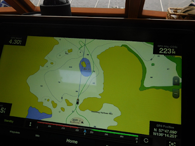
From Klag Bay we headed over to Goulding Harbor. This was another place where we found the
electronic charts to be inadequate. The Douglas book warns of the issue as it
says “Goulding Harbor is poorly charted, so caution is required. We found an
uncharted rock reef! We always go cautiously and we saw it outside the pilot
house door so we had to make a quick reverse with the big boat. You can see our
tracks on the chart – the unmarked reef is on the right side of the boat but
the shallow section shows on the left in one of the charts. I have attached the charts to give you an
example of the issues with inadequate charts. In one chart it shows a 54 ft
depth, in another 6 ft. Both Garmin charts. I have also attached a photo of the
two islands- I took it from the opposite direction when we left the harbor - we had go to the right of the island on the
right. You can see our track on the
chart where we had to back up – the reef extended from the island on the left
all the way to where the boat was with about 2 feet of water above it.


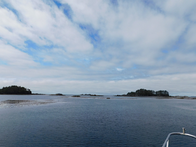
The harbor was a beautiful spot and we got to see Grizzlies
again. One even reared up on its hind legs – sorry my picture is not the best!
In the picture with the bear on its hind legs you can also see a second bear to
the left by the trees.


We woke up on July 5th to another gray, cold day.
We must head back outside on the Gulf of Alaska to round the point and head
into the West Arm of Mirror Cove. It is
about 4 ½ miles of open ocean and we are expecting ocean swells but it is a
short distance and once we get there we will be able to take a trail on the
beach to the White Sulfur Hot Springs about 1 mile away.

No comments:
Post a Comment