Tuesday 28 May 2013


Ketchikan thru Misty Fiord National Monument to Walker Cove – May 26 – May 28th, 2013

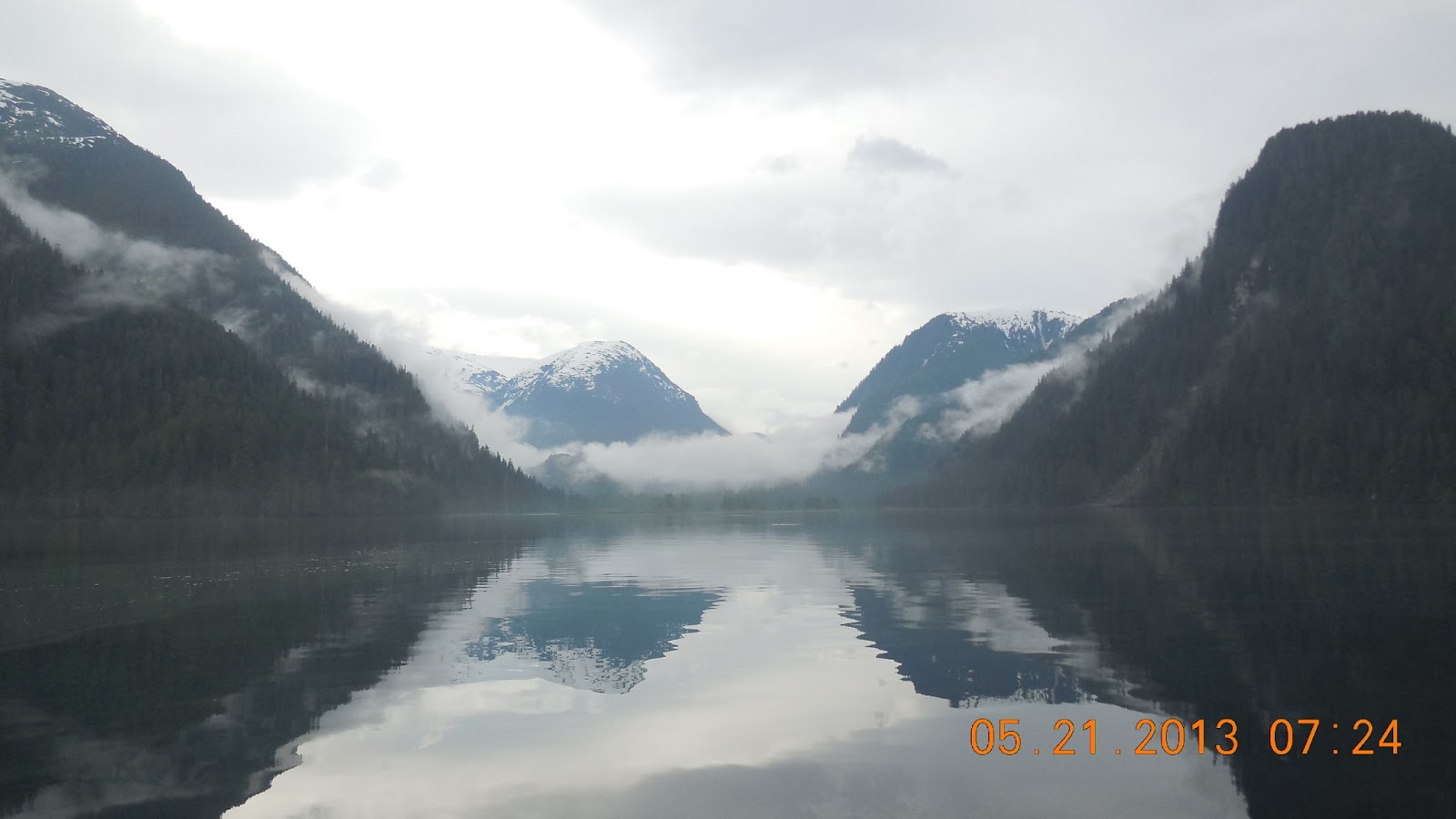
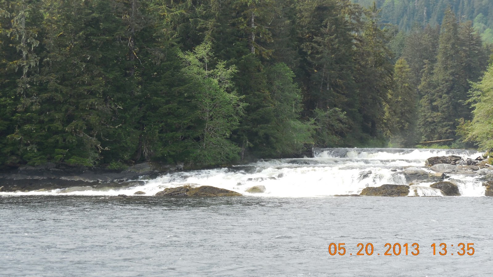
     Just when we think it can't possibly get more beautiful, it does.  We decided to spend a few days in the Misty Fiords National Monument.  It was established in 1978 and encompasses 2.2 million acres.  It is accessible only by float plane or boat.  We spent our first night off of Carp Island which was about a 3 ½ hour cruise from Ketchikan.  From Carp Island we went North thru the Behm Canal to Punchbowl past an amazing site called the New Eddystone Rock.  It is a 230 foot rock right in the middle of the channel that looks like something out of the hobbit – it is a mystical looking tree covered rock.  The cruise to Punchbowl took us about 3 hours in beautiful weather again.

  Punchbowl is impossible to describe how beautiful it is – I am going to just post pictures so you can see for yourself.  It is amazing and we took the dinghy’s all the way to the end of the Cove.  It is surrounded by a 3000 foot granite faced mountain and is breathtaking.  We had dinner aboard the Nelsea with all 11 of us and decided that it is time to have movie night tomorrow so we can share and see everyone's pictures.  I have probably over 600 myself so it may be a very late night!

  We spent the night in Punchbowl and were treated to an amazing lightning and thunder display but woke up to sunshine and another incredible day.  
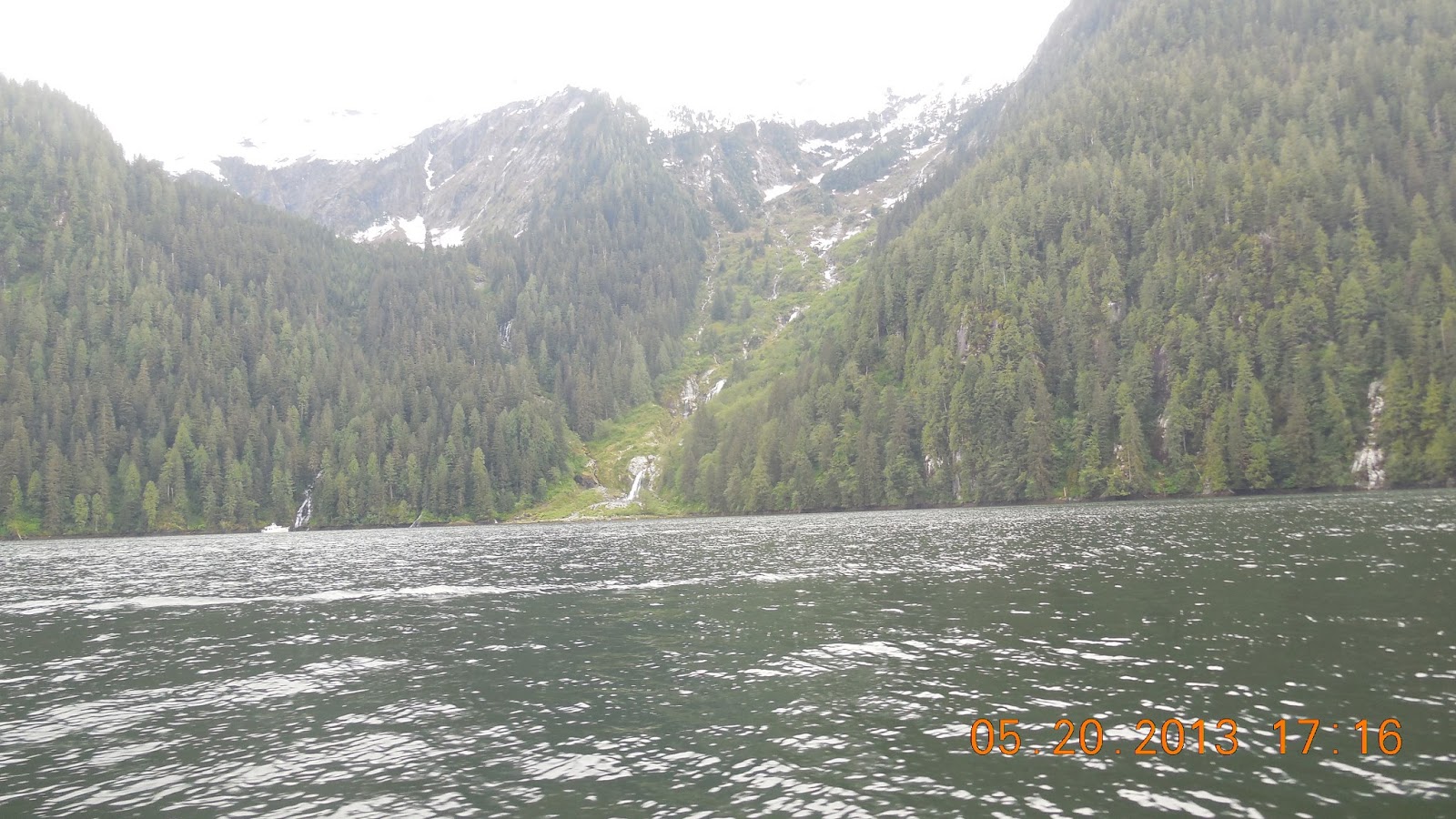
We travelled up Behm Canal and took a detour up the Walker Cover as it is another spectacular fiord with a glacier carved valley at the head.  We spent about an hour going to the head of the Canal but it was another spectacular sight with waterfalls, snow covered mountains and canyons.  Some of the waterfalls plunge down the granite walls over 1 mile to the water – almost straight down!

     Now we are cruising to Fitzgibbon Cove where we are going to spend the night anchored in a cover that offers good shelter from the winds as the weather appears to be changing again.  We have had a spectacular sunshine cruise so far but you can watch the clouds rolling in and the water get rougher.  We have to remind ourselves that this is a rainforest and usually gets at least ½ inch of water a day so we have been extremely fortunate on the weather here also. I am going to post a picture that shows us entering Walker Bay and then leaving one hour later and it shows just how quickly the weather changes.


Prince Rupert to Ketchikan May 25, 2013


Prince Rupert to Ketchikan  May 25, 2013

     We left our anchorage in Salt Lake Provincial Park which is across the Harbor from Prince Rupert.  It was a 0 tide today about 8:00 so we left a little before 7:00am for our route thru Venn Passage.  A very twisty, shallow passage where the lowest depth we registered was about 10 feet. It was expected to go down about 4 more feet than when we went thru the area so definitely worth getting up a little earlier!  Once we cleared all the rocks, shoals and fishing vessels we headed North for Ketchikan.  I keep telling you what spectacular weather we are having - from what we have heard this is not normal for May.  It is partly cloudy with great visibility and the water is smooth.  We are passing by Dundas Island where we will cross the Dixon entrance for Ketchikan.  We expect the trip to take about 9 hours from Prince Rupert to Ketchikan (approx. 86 miles- yes we still go slow!)

     Our plan is to meet up with Pete and Linda on the Rendevous, spend the night in Ketchikan and restock the boat with fresh foods then head out to Misty Fiords National Monument.  It is the area often called the Banana Belt as it has mild temperatures and winds and seas that are less changeable and extreme. It gets plenty of rain with an average of over half and inch per day but has magnificent scenery and wildlife and is known for world class salmon fishing.

Friday 24 May 2013

Pictures - May 21 - May 23


More pictures!
Add caption

Pictures of the Trip from May 21 - May 24

I will update this later with descriptions of where we are but we are limited on internet connection so I wanted to get some posted. May 19th and 20th and you can see the incredible weather we are having on the trip.  The pictures do not do it justice as the scenery is so spectacular!


Bishop Bay, Lowe Inlet, Baker Inlet, Prince Rupert May 21 - May 24th, 2013


May 21 – May24, 2013    Bishop Bay to Lowe Inlet – Lowe Inlet to Baker Inlet –Baker to Prince Rupert

     We left Bishop Bay today in beautiful sunny skies for our travels to Lowe Inlet.  We got satellite phone service so we were able to check in with everyone and also find out how Pete and Linda are doing on Rendevous.  They made it to Ketchikan yesterday so they are hoping to start boat repairs on Friday.  The winds have been picking up so we will probably not cross until Saturday or Sunday.  Pete and Linda decided to make some really long days of it to get to Ketchikan which is great as they hope to join up with us as soon as possible after the repairs.  We have been watching the forecast and are just taking our time.  We had another beautiful sunny day today and even put on shorts and t shirts for the cruise.

     We crossed from Tolmie Channel into Fraser Reach across Wright Sound into Grenville Channel for our trip up to Lowe Inlet.  We stayed in the Nettle Basin which has a beautiful waterfall named Verney Falls at the head of the Inlet.  The Kumowdah River flows into Lowe Lake which is about a ½ mile hike along the river- the lake drains over Verney Falls – Glen and Nat took the ½ mile hike to the Lake and said it was very hard – they came back soaking wet from sweat and looking like they had fallen in the water.  This was definitely a popular site- we ended up with 4 additional boats in the bay with the 5 of our RHYC Armada.  We saw a black bear feeding in the river in the evening and the highlight was when he went back to the trees for a big back scratch – just like Baloo from the jungle book! He was too far away for pictures but great viewing thru the binoculars.

    May 23 – Hazy skies for our trip to Baker and very windy.  Baker is only about a 17 mile trip up Grenville Channel and is supposed to be one of the most protected anchorages in the channel and one of the last fairly secluded ones as we are getting close to Prince Rupert where we will cross to Ketchikan.  The entrance to Baker Inlet is a narrow channel – maybe 20 yards called Watts Narrows – very beautiful  but can definitely be a challenge when the water is running.  We arrived in a strong current flowing in and it pushed us thru the channel into a beautiful bay – it looked like a Swiss alps lake surrounded  by huge 3000 foot peaks but the bay was calm and we had sunny skies to explore in the dinghy.   Josh and Tyler you will be happy to know we caught shrimp in the new pot! 

   May 24 – We woke up today to the weather I have been expecting – pouring with rain and heavy overcast.  We decided to get thru Watts Narrows before we would have to wait until afternoon to get out of Baker Inlet.  Even leaving shortly after low tide it had switched and was running at 4 knots against us but a little extra power and we are on our way to Prince Rupert. This will be our last stop in BC before heading to Ketchikan either tomorrow or Sunday.  The winds will determine which day we go!  I will post pictures in Prince Rupert if the internet is fast enough – otherwise pictures will follow in Ketchikan.

Happy Memorial Day Weekend to everyone!

Alexander Inlet to Khutze May 19th - May 20th, 2013


Alexander Inlet to Khutze  May 19th to May 20th, 


     We left Alexander Inlet about 11:00 for our cruise to Khutze.  We will be cruising for about 4 hours today.  It is a beautiful sunny day, clear but cool although we are cruising from the top today in the sunshine.  We are in the Tomie channel for about 24nm which is bordered on both sides by high hills. Tom and Chris were cruising just off the shore In over 300 feet of water so there  are steep hills on either side ( 1600 – 3300 Ft). Yesterday we saw a momma humpback whale and baby so we are on the lookout today also.

     We have seen lots of waterfalls today – the snow up high is melting and the water is pouring out of the hills.  We have also seen abandoned pulp mills from the 1930’s on the channels sides.  We arrived in the Khutze Inlet and for the first time this trip we are anchoring in a bay with another boat! The inlet is about 4 miles long.  At the head of the inlet is a river that we decided to go up in our dinghy.  We made it about ¾ miles before we were down to a foot of water and had to turn back.  It had a strong current and the river valley was beautiful.  The book said we could go on a 3 mile walk up the river valley to an old abandoned gold mine but it was late in the day when we got there so maybe next time!

     We had a fresh seafood paella feast on Reflections and plan on leaving tomorrow for Bishop Bay where there is a hot springs.  Tomorrow will be a homemade Chowder using the Goeduck we were given by some fishermen in one of the bays.

Shearwater to Alexander Island May 19, 2013


Shearwater to Alexander Island May 19, 2013


  We headed out of Shearwater about 9:30 for our cruise to Alexander Inlet.  Travelling NW thru Seaforth  Channel was quite lumpy today – about 3 – 5 foot seas until we got to Ivory Island and headed north thru Reid Channel between Cecilia Island and Don Peninsula.  A beautiful passage and it is sunny but cold – 59 degrees! On past Lady Douglas and Lake Island thru Mathieson Channel which has places 1000 feet deep.  Next we cut thru Jackson Passage to Finlayson channel. Jackson Passage was at low tide so it was very narrow and we got as low as 10 ft depth. 

    A couple of us went on the inside of Cone Island to pass by Klemtu –home to the Kitasoo and Xai’xais tribes.  We had cell coverage there so took the opportunity to call the boys , my mom and our neighbors Allen and Sue.  Now we are on our way to towards Tolmie Channel and our stop for the night at Alexander Inlet.  We cruised for about 6 hours today.


Sunday 19 May 2013

Bella Bella to Shearwater


Codville - Sagar Lake


Steve and Tom on trail and Sagar Lake.

Photos from Calvert Island


Rendevous, Magic Moment, Panacea, Miner's Debt, Nelsea and Reflections in Adams Harbor

West Beach on Calvert Island

Hakai Institute dock on Calvert Island

Leaving Calvert for Codville

Saturday 18 May 2013


Nelsea Adventures May 17 – May 18th

   We arrived to Codville Lagoon just in time for the rain to start.   We now have 5 boats in the RHYC Armada as Rendevous went into Shearwater for boat issues.  They are heading on to Ketchikan to have the repairs made as getting parts to Shearwater was going to take quite awhile.

     Most of us decided to do the hike/walk to Sagar Lake and left about 4:00. We walked thru the woods parts on a boardwalk, the rest thru the woods over vines and trees. Very muddy so we were glad we worn our rainboots!  It was about 1/2 mile to the lake but well worth the hike – a beautiful lake and it stopped raining momentarily just as we got there.  Sandy beach, peaceful and serene.  Back to the boats and dinner of salmon and tuna - then to Glen and Liz’s boat for the evening showing of The Life of Pi.

     Today it is pouring rain, heavy overcast and completely socked in.  We are off to Shearwater thru Lama Pass.  We will cruise for about 2 hours today then explore Shearwater.   

Nelsea Adventures May 15- May 17th

   We left Port McNeill on May 15th at 4:00 in the afternoon after several boat issues with other boats travelling with us from the RHYC Armada. The Nelsea is doing great – a few issues but nothing to hinder our trip.  It probably worked out for the best that some of us got a later start as the winds started to subside by the time Miner’s,  Mehlum’s and the Nelsea left the dock. The other 3 boats left a few hours before us and had a fairly bumpy ride.    

   We cruised up the rest of Vancouver Island, took a ride thru Coletas Channel  to Hope Island which is right across from the North End of Vancouver Island. We finally anchored at about 8:30.  We paired up – two boats to an anchor so Chris and Tom tied up to our boat, Collier’s and Mehlums, and Dodge and Jung.   We were well protected in Bull Harbor and got up the next morning with a 7:00am departure time to cross Queen Charlotte straits.  It was a calm morning, no wind but fog rolled in just before our departure time.  We all left with radar and at times the visibility was less than ¼ mile but by the time we reached Cape Caution(25 miles approx- 2 ½ hours – yes we go slow!) we broke out of the fog and it was a beautiful day. We travelled for about 6 hours thru Klaquaek Channel and ended up in Adams Harbor on Calvert Island.

     We spent the afternoon of May 16th exploring the beautiful West beach on the Pacific Ocean. We took our dinghy’s from Adams Harbor down to Pruth Bay which is at the western end of Kwakshua Channel.  The Hakai Institute has a beautiful facility there where you can tie up your dinghy’s and walk on a trail for about a ½ mile to the West Beach which is stunning. Beautiful white sand, surf rolling in with small islands off the beach and the sun decided to come out during our time on the beach.  Then back to the boats where we had fresh clams, Nat’s oysters, smoked salmon and fun company on the Collier’s boat – Reflections.

   This morning the fleet left Adams Harbor for Codville Lagoon on King Island with a stop in Namu.  It used to be a cannery facility but BC Packers walked away from Namu in the 80’s leaving everything behind.  Trucks,  fork lifts, equipment, a fully stocked store.  The entire place is falling down now.  It has been for sale for over 20 years but must be an environmental nightmare. There are caretakers living there but basically tell you to walk around at your own risk.  Buildings caving in, dock falling apart. 

We left Namu for Codville  Lagoon about 1:30 – we are cruising for about 3 hours total today(approx 26 miles) thru the Fitzhugh Sound.   

Wednesday 15 May 2013

Pictures from the first week aboard the Nelsea

Here are some more pictures


The first edition of Nelsea adventures from Port McNeil BC. Our plan is to leave here today Wednesday May 15th for Bull Harbor with a plan of crossing over past Cape Caution tomorrow. I finally got the blog up but might not have phone or internet for awhile to update this Blog.  It took us longer than anticipated to get it up and running!
   Everything is going great - We left Port Orchard on May 8.  Stayed overnight at Port Madison then on to Roche Harbor/Henry Island.  We left for Nanaimo where we cleared customs and provisioned with fresh stuff that we could not bring into Canada and spent the night at the Nanaimo Yacht Club. From Nanaimo, we ended up having an 11 hour day so that we could get all the way to Shoal Bay since the tide change was at 7:00 at night. We were with Chris and Tom and we voted for going all the way in one day as the other option was to get up at 4:00am to hopefully catch the morning tide which did not sound good to any of us!  It turned out to be a great call  as we really did well on fuel consumption - we were pushed thru the 3 rapids and got into Shoal Bay before dark!  We had a great cruise to  Port Harvey and enjoyed an early day.  The other Roche Harbor Yacht Club (RHYC) boaters met up with us there later in the afternoon.  We had been behind them by 1 day until we went on to Shoal Bay.  They opted to go for the crossing during the day and it was a long 7 hours for them bucking the currents. We had appetizers of fresh clams on the dock and caught up with everyone.  Thanks for the clams Linda!  The next day Chris and Tom(Steve's sister and brother in law), Glen and Liz Dodge and Steve and I went on to Mound Island where Chris saw the first black bear of the trip. We spent the night at Anchorage in a beautiful spot - steaks on the barbeque with fresh asparagus and an evening movie on Liz and Glen's boat the Magic Moment.  The movie was Flight with Denzel Washington and I have to say I would not recommend it!  The next morning it was on to Port McNeill to meet up with everyone from RHYC and a dinner out at Gus's Pub!  Great fish and chips and company.

The picture is at Shoal Bay - Nelsea on the Right and Miner's Debt with No Debt on the left!  Miner's Debt is Chris and Tom's boat- a 43' Mainship.

More to come later -  Steve and Michelle